3D DATA FOR MIDDLE EAST
3D CITIES OF MIDDLE EAST 2020
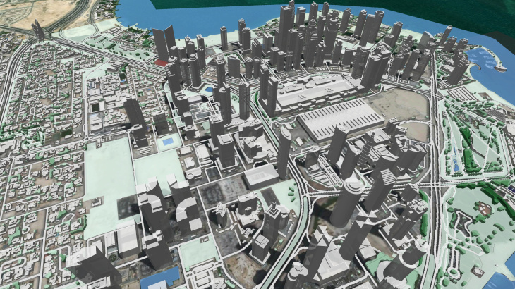
In urban areas with fewer propagation distances, dense and high-rise buildings, sometimes complicated relief, the accurate 3D geodata is an essential component of RF design: accurate simulation to support deployment, operation, and optimization of mobile networks.
We use recent vintage high-resolution stereo imagery to create 1 or 2 or 5 m geodata in LOD2 quality. 3D geodata accuracy – 2-3 m in x,y,z.
This project includes the following cities and countries:
| COUNTRY: BAHRAIN | |
|---|---|
City | Area |
| Full 3D Country Model of BAHRAIN | 791 sq.km |
Download the free 3D data sample of Manama city model. to see more details.
| COUNTRY: OMAN | |
|---|---|
City | Area |
| City model of BAHLA | 17 sq.km |
| City model of DUQM | 58 sq.km |
| City model of IBRA | 43 sq.km |
| City model of IBRI | 45 sq.km |
| City model of JALAN BANI BU HASSAN | 66 sq.km |
| City model of NIZWA | 51 sq.km |
| City model of QURIYAT | 10 sq.km |
| City model of SALALA | 86,6 sq.km |
| City model of SINAW | 10 sq.km |
| City model of SUR | 39 sq.km |
| City model of TILKAI | 4 sq.km |
TOTAL | 429.6 sq.km |
Download the free 3D data sample of MUSCAT city model. to see more details.
| COUNTRY: QATAR | |
|---|---|
City | Area |
| 3D model for rf planning of DOHA | 1312 sq.km |
Download the free 3D data sample of DOHA city model. to see more details.
| COUNTRY: UNITED ARAB EMIRATES | ||
|---|---|---|
City | Area | Number of LOD1 Buildings |
| 3D Map of ABU DHABI | 473 sq.km | 132048 |
| 3D Map of AJMAN | 65 sq.km | 50621 |
| 3D Map of DUBAI | 1628 sq.km | 296543 |
| 3D Map of FUJAIRAH | 50 sq.km | 28885 |
| 3D Map of RAS AL KHAIMAH | 151 sq.km | 82248 |
| 3D Map of SHARJAH | 169 sq.km | 96017 |
| 3D Map of UMM AL QUWAIN | 45 sq.km | 17440 |
| TOTAL: | 2578 sq.km | 703802 |
Download the free 3D data sample of UAE city model. to see more details.
| COUNTRY: EGYPT | |
|---|---|
City | Area |
| 3D City Model of CAIRO | 2587 sq.km |
Download the free 3D data sample of CAIRO city model. to see more details.
Digital Surface Model (DSM), Digital Terrain Model (DTM) and Digital Elevation Model (DHM) were produced based on 3D terrain features which were derived from overlapping satellite imagery is taken from two different locations (stereo imagery).
Highly accurate building vectors with associated height values as attributes are captured through three-dimensional feature extraction in our photogrammetric software.
Clutter/Land Use/Land Cover describes the surface and built-up features that influence radio wave propagation. They are classified into different classes: classes of built-up areas, water classes, classes of landscape and vegetation. Urban Land Use map is produced from multispectral satellite imagery by the method of automatic classification with subsequent manual photo-interpretation and modification.
Download the booklet about project "3D RF map of Middle East" to see more details.
Usually, outside the areas of 3D city coverage, operators still require geodata for RF planning and optimization in suburbs. We propose 2D Urban Model, 2.5D Urban Models, 2D Regional Models with clutter height with 5, 10, 20 m resolution, with DTM, clutter (land use) and vector layers. Our geodata catalogue includes over 1500+ 3D City Models, 4500+ cities 2D Urban Models and 65+ Coutrywide model for regional planning.
Send us the request for more information


