3D Maps
Visicom's 3D maps
Visicom produces digital 3D maps for any territory providing customized solutions for each client
Various levels of detail can be applied for various application supporting their specific demands and providing navigation data, building textures, roof details, 3D vegetation, addresses database, streets name in a local language, POIs, etc.
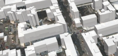
3D Maps are based on stereo pairs of high-resolution satellite imagery and air phots.
Applications:
- Environmental Management and Modeling
- Urban Planning
- Building Information Modelling
- WEB-Applications
- Virtual Games
- Territorial Marketing
- Tourism
- Planning of Utility Networks
- Real Estate
- Marketing
- Disaster Risk Management
- Wireless Networks Planning
- mm-wave Planning (5G Planning)
- Smart Cities
- Solar Smart Energy Planning and Solar Cadastre
Our geodata portfolio includes 2500+ 3D Maps over the world.
- LoDs 1.0 and 1.1 buildings
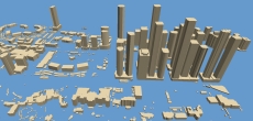
- LoDs 1.2 and 1.3 buildings
- LoD 2 buildings

- LoD 2 buildings + 3D Trees

We guarantee
- Precise and up-to-date mapping information
- Extra-accurate 3d buildings
- Detailed and high-resolution terrain
- Flexible price fitted to customer budget
- Delivery in any RF planning tool and GIS format
Data formats
- Alcatel A955
- Aircom Asset
- Atoll Forsk
- CelPlanner
- ICS Telecom
- NetPlan
- AutoCAD
- ESRI ArcGIS
- MapInfo
- Microstation
- Neva
- Odyssey
- Pathloss
- Mentum Ellipse
- Mentum Planet
- Nokia NetAct
- ASCII XYZ
- Raster images
- TIFF and GeoTIFF
- ERDAS Imagine Image
- ER Mapper Raster
- ENVI Image Format
- Generic Binary
Order product