3D GEODATA FOR MAJOR ROMANIAN CITIES
3D GEODATA FOR MAJOR ROMANIAN CITIES
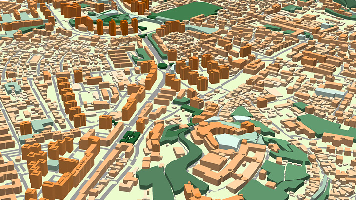
3D city models produced for Atoll RF planning tool and cover 1334 sq.km area of major Romanian cities:
- Brasov – 130 sq.km
- Bucharest – 410 sq.km
- Cluj – 116 sq.km
- Constanca –179 sq.km
- Craiova – 147 sq.km
- Iasi –125 sq.km
- Oradea – 127 sq.km
- Timisoara – 100 sq.km
Data contain Digital Terrain Model (DTM), Highly accurate 3D Buildings with roof details, 3D Vegetation and Bridges, Clutter/Land Use/Land Cover, Obstacles (Clutter) Heights, Transportation networks and Population map. 3D geodata accuracy – 2-3 m in X,Y,Z.
Our geodata made specifically for telecom industry provide precise knowledge about the 3D environment in order to help operators design and improve the performance of their radio networks. 3d network planning for 5g.
Visicom’s advanced mapping products support any RF tool format (Atoll, Asset, Planet, Mentum Planet, Pathloss etc.)
Learn more about 2.5D Urban Models for suburbs as more cost-effective solution, 2D Models for regions and countrywide coverage.
Download the free data sample of Bucharest digital model in order to explore more details.
Our geodata catalogue includes over 4000 cities and 80+ countries.
Send us your request for more information


