3D MODEL OF CIUDAD REAL WITH HEIGHTS ATTRIBUTE SLOPED ROOFS
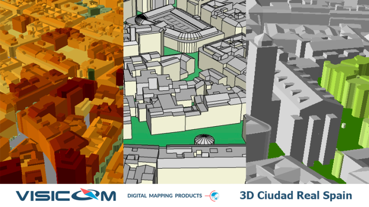
3D MODEL OF CIUDAD REAL WITH HEIGHTS ATTRIBUTE SLOPED ROOFS
In urban areas with fewer propagation distances, dense and high-rise buildings, relief, the accurate 3D geodata is an essential component of RF design: accurate simulation to support deployment, operation and optimization of mobile networks. Also, this quality and heights set of geodata can be used in Solar energy planning and Solar Cadastre.
3D City model of Ciudad Real (Spain) covers the old part of the city. We use recent vintage stereo imagery of 0.3 m resolution to create 2 m high-resolution geodata in the most accurate quality LOD2. 3D geodata accuracy – 2-3 m in x,y,z.
Digital Surface Model (DSM), Digital Terrain Model (DTM) and Digital Elevation Model (DHM) were produced based on 3D terrain features, which were derived from overlapping satellite imagery is taken from two different locations (stereo imagery).
The highly accurate building vectors with associated height values as attributes are captured through three-dimensional feature extraction in the photogrammetric apps.
Clutter/Land Use/Land Cover describes the surface and built-up features, which influence on radio wave propagation. They are classed into different classes: classes of built-up areas, water classes, classes of landscape and vegetation. Urban Land Use map is produced from multispectral satellite imagery by the method of automatic classification with subsequent manual photo-interpretation and modification.
Download the booklet about the project "3D model and RF map of Ciudad Real (Spain)" to see more details.
Usually outside the areas of 3D city coverage, operators still require geodata for RF planning and optimization in suburbs. We propose 2D Urban Model, 2.5D Urban Models, 2D Regional Models with clutter height with 5, 10, 20 m resolution, with DTM, clutter (land use) and vector layers. Our geodata catalog includes over 4000 cities and 60+ countries.
Applications:
- Environmental Management and Modeling
- Urban Planning
- Building Information Modelling
- WEB-Applications
- Virtual Games
- Territorial Marketing
- Tourism
- Planning of Utility Networks
- Real Estate
- Marketing
- Disaster Risk Management
- Wireless Networks Planning
- mm-wave Planning (5G Planning)
- Smart Cities
- Solar Smart Energy Planning and Solar Cadastre
Send us the request for more information


