3D MODEL OF MANDALAY (MYANMAR)
3D MODEL OF MANDALAY
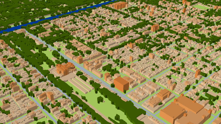
In urban areas with less propagation distances, dense and high-rise buildings, sometimes complicated relief, the accurate 3D geodata is an essential component of RF design: accurate simulation to support deployment, operation and optimization of mobile networks.
3D City model of Mandalay covers 215 km2. We use recent vintage stereo imagery 0.3 m resolution to create 2 m high-resolution geodata in LOD2 quality. 3D geodata accuracy – 2-3 m in x,y,z.
Digital Surface Model (DSM), Digital Terrain Model (DTM) and Digital Elevation Model (DHM) were produced basing on 3D terrain features which were derived from overlapping satellite imagery taken from two different locations (stereo imagery).
Highly accurate building vectors with associated height values as attributes are captured through three-dimensional feature extraction in our photogrammetric software.
Clutter/Land Use/Land Cover describe the surface and built-up features which influence on radio wave propagation. They are classified into different classes: classes of built-up areas, water classes, classes of landscape and vegetation. Urban Land Use map is produced from multispectral satellite imagery by method of automatic classification with subsequent manual photo-interpretation and modification.
See also regional map of Myanmar and 3D City model of Yangon
Download the free data sample and booklet about project "RF map of Myanmar" to see more details.
Usually outside the areas of 3D city coverage, operators still require geodata for RF planning and optimization in suburbs. We propose 2D Urban Model, 2.5D Urban Models, 2D Regional Models with clutter height with 5, 10, 20 m resolution, with DTM, clutter (land use) and vector layers. Our geodata catalogue includes over 4000 cities and 60+ countries.
Send us the request for more information


