3D MODELS OF SUDANIAN CITIES
2017-08-22
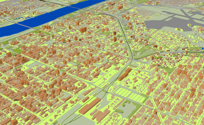
3D MODELS OF SUDANIAN CITIES
Project for Radio Frequency planning, Geoinformation System and WEB-applications and contains:
data for RF planning:
3D model of Khartoum – 660 sq km including:
- 3D model of Khartoum – 206 sq km;
- 3D model of Omdurman – 208 sq km;
- 3D model of Khartoum Bahri – 173 sq km;
- 3D model of Um Badda – 53 sq km;
- 3D model of South Khartoum – 15 sq km;
- 3D model of Karary – 5 sq km.
3D model of Port Sudan – 60 sq km. 3D model of Wad Madani – 49 sq km.
data for GIS project and WEB project:
Map of Khartoum – 660 sq km including:
- Map of Khartoum – 206 sq km;
- Map of Omdurman – 208 sq km;
- Map of Khartoum Bahri – 173 sq km;
- Map of Um Badda – 53 sq km
- Map of South Khartoum – 15 sq km
- Map of Karary – 5 sq km
Map of Port Sudan – 60 sq km
Map of Wad Madani – 49 sq km
Project package includes 3 types of data representation:
- Vector data model provided as a composition of vector layers in ESRI ArcGIS or Mapinfo formats.
- Raster data model presented in Geo-tif format and includes:
• Digital Elevation Model (DEM) (data placed in Height.tif file);
• Land Use Map (Clutter Model) - Service Data for RF planning tools:
• Digital Terrain Model (DTM);
• Land Use Map (Clutter Model) in matrix representation;
• Text labels;
• Vector layers.
Share this story


Order product