GEODATA FOR GERMANY
DIGITAL MAPS OF GERMAN CITIES FOR 5G NETWORKS PLANNING
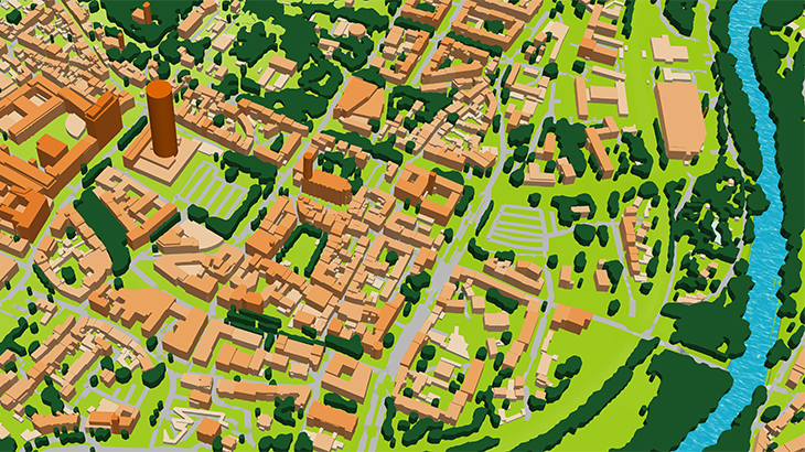
🔔 We would like to propose accurate 3D maps for the 5G network pre-planning phase for a reasonable level of prices.
Visicom ® produces high-level geodata for 5G planning because we have 20 years of experience to cooperate with telcos and operators world wide.* That is why you can be sure of the quality of our products.
We have 3D buildings and vegetation models for 5G network planning which are fully optimized for use with Millimeter Wave (mmWave) frequencies and can be used in different tools like Atoll, Asset, Planet, ICS etc.
2.5D – 3D CITY MODELS, 5m resolutions
✅ Berlin – 1062 Area, km2
✅ Cologne – 625 Area, km2
✅ Frankfurt – 248 Area, km2
✅ Hamburg – 770 Area, km2
✅ Jena – 119 Area, km2
✅ Leipzig – 370 Area, km2
✅ München – 651 Area, km2
More cities will be available soon.
Content of 3D models:
- DTM
- Land Use/Clutter Model
- Clutter Heights Model
- 2D building layer with an indication of the height
- Basic vector layers: roads, streets, water lines etc.
⚠ Our geodata catalogue includes over 5000 cities across 120+ countries.
✉ Contact us to receive a free sample of the 3D city Model.


