2.5D Geodata for rural areas
2.5D Geodata for rural areas
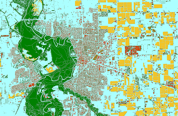
To meet the challenges of 5G networks design outside of cities, Visicom produces 2.5D Models that add height values to buildings and vegetation features in suburbs and rural areas. Usage of 2.5D Models provides precise and cost-effective modelling of obstacles heights over large areas like in urban and integrated planning process inside and outside of the cities.
FROM 5M UP TO 20 M RESOLUTION MODEL OF REGIONS/VILLAGES/RURAL AREAS
- 2.5D BUILDINGS - Buildings and blocks with assigned height attributes, 3-5 m accuracy
- 2.5D VEGETATION - Detailed vegetation with assigned height attributes, 5 m accuracy
- 2D LINEAR VECTOR - Street network, railroads, boundaries
- DSM/DTM - 3-5 m accuracy in terrain features
- CLUTTER/LANDUSE - Includes all landuse features and detailed vegetation layer
- DATA FORMAT - Compatible with any RF planning software
Download brochure: 5G planning in rural areas
Download free 2.5D Regional Geodata SAMPLE
Explore more
We guarantee
- Precise and up-to-date mapping information
- Extra-accurate 3d buildings
- Detailed and high-resolution terrain
- Flexible price fitted to customer budget
- Delivery in any RF planning tool and GIS format
Data formats
- Alcatel A955
- Aircom Asset
- Atoll Forsk
- CelPlanner
- ICS Telecom
- NetPlan
- AutoCAD
- ESRI ArcGIS
- MapInfo
- Microstation
- Neva
- Odyssey
- Pathloss
- Mentum Ellipse
- Mentum Planet
- Nokia NetAct
- ASCII XYZ
- Raster images
- TIFF and GeoTIFF
- ERDAS Imagine Image
- ER Mapper Raster
- ENVI Image Format
- Generic Binary
Order product