Digital Surface Model (DSM)
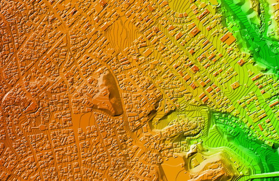
Digital Surface Model
Digital Surface Model (DSM) that includes ground surface, vegetation and man-made objects
DSM demonstrate the natural and artificial features on the Earth’s surface.
Digital Surface Model may be useful for RF planning, landscape modelling, city modelling, visualization applications and more
See also another types of digital elevation models:
- Digital Terrain Model (DTM)
- Digital Heights Model (DHM)
We guarantee
- Precise and up-to-date mapping information
- Extra-accurate 3d buildings
- Detailed and high-resolution terrain
- Flexible price fitted to customer budget
- Delivery in any RF planning tool and GIS format
Data formats
- Alcatel A955
- Aircom Asset
- Atoll Forsk
- CelPlanner
- ICS Telecom
- NetPlan
- AutoCAD
- ESRI ArcGIS
- MapInfo
- Microstation
- Neva
- Odyssey
- Pathloss
- Mentum Ellipse
- Mentum Planet
- Nokia NetAct
- ASCII XYZ
- Raster images
- TIFF and GeoTIFF
- ERDAS Imagine Image
- ER Mapper Raster
- ENVI Image Format
- Generic Binary
Order product